Location
Location & Connectivity — Sattva City Doddajala

Sattva City location Doddajala is arguably the single most strategic stretch of North Bangalore, the stretch of NH-44 that lies between the city core and the Kempegowda International Airport. The micro-market has emerged in the last five years as the natural northward extension of the Yelahanka-Hebbal axis, its growth a function of airport-linked employment density, planned metro infrastructure and the maturing aerospace and financial services corridor which anchors the surrounding land.
If you are an end-user purchase or long-hold investment buyer, choosing the location of Sattva City Doddajala means choosing direct exposure to the capital appreciation story of the airport-corridor. The project is around 8.5 km from Kempegowda International Airport, around 4.5 km from Doddajala Metro Station, Phase 2B and around 10 km from KIADB Aerospace SEZ, one of the largest aerospace and defence employment clusters in India. This micro-market sets the per-square-foot benchmark it does because of the structural reason of present-day connectivity and future-state infrastructure.
Airport, Metro and Highway Connectivity
With direct access to NH-44 / Bellary Road, the airport is a sub-15-minute drive in normal traffic, while residents can take the toll-bypass route through Bellary Road to avoid the elevated expressway and NICE Road tolls while heading to central Bengaluru. Once operational, the Doddajala Metro Station will lend the project a future-ready public-transit profile that few competing launches in the airport corridor will be able to equal. The commissioning of STRR will further integrate Sattva City Doddajala into the broader Bengaluru Metropolitan Region Road network.
Connectivity highlights for the Sattva City location Doddajala include:
Kempegowda International Airport — Approx. 8.5 km via NH-44 (toll-bypass route available)
Doddajala Metro Station (upcoming) — Approx. 4.5 km within Phase 2B alignment
Yelahanka Junction — Approx. 12 km on signal-thinned arterials
Hebbal Flyover — Approx. 20 km via NH-44
Outer Ring Road (ORR) — Approx. 21 km
KIADB Aerospace SEZ — Approx. 10 km
IFCI Financial City — Approx. 11 km
Devanahalli Business Park — Approx. 12 km
Prestige Tech Cloud — Approx. 14 km
Manyata Tech Park — Approx. 23 km via signal-thinned NH-44 service road
Phoenix Mall of Asia — Approx. 18 km
Manipal Hospital Yelahanka — Approx. 14 km
Taj Bangalore (hospitality anchor) — Approx. 10 km
Schools, Hospitals and Lifestyle Anchors
The Sattva City near Bangalore airport context too offers a thick layer of schools, healthcare, retail and hospitality within a comfortable drive radius. The international and Indian-curriculum education cluster includes Stonehill International School at 9 km, Harrow International School at 10 km, Canadian International School at 16 km and Delhi Public School North at 15 km. Multi-specialty healthcare coverage from 14 to 20 km from Manipal Hospital Yelahanka, Sparsh Hospital, Cytecare and Aster CMI. The retail and lifestyle level will be handled by Phoenix Mall of Asia, Forum 13 Degree North and RMZ Galleria.
View the official location pin: Sattva City on Google Maps
Frequently Asked Questions
Latest Blog

Sattva City Construction Updates and Quality Standards
Sattva City construction quality updates — RCC framed structure, construction timeline, quality control standards, and milestone progress at Doddajala.

How to Download the Sattva City Brochure and What's Inside
Sattva City brochure download guide — how to access the official brochure, what's inside including master plan, floor plans, amenities, specifications, and pricing details.
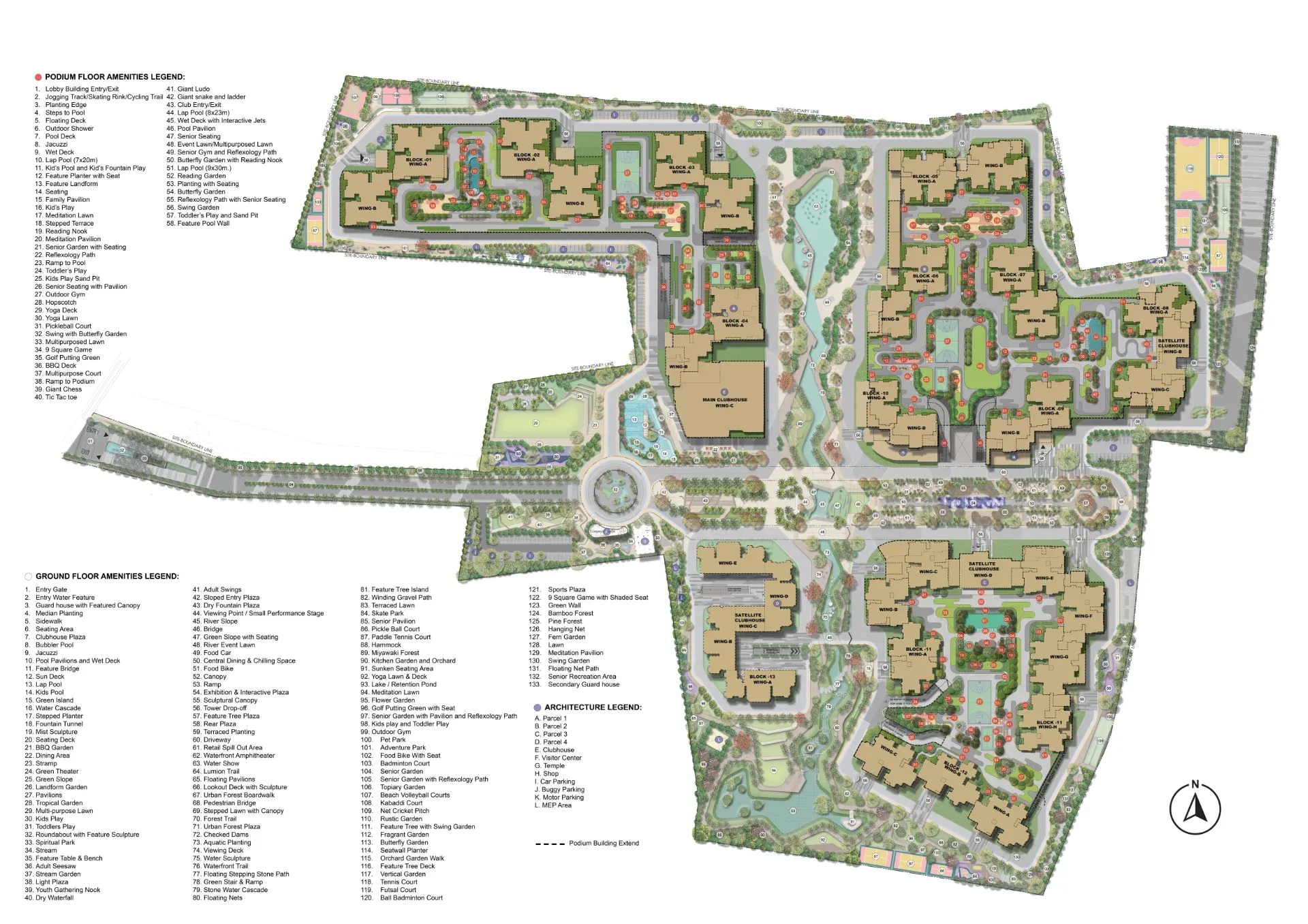
Inside the Sattva City Master Plan: 49 Acres Across 13 Residential Towers
Sattva City masterplan analysis — detailed look at the 49-acre layout, 13-tower configuration, podium planning, and landscape strategy at Doddajala.

When Will Sattva City Launch? Booking Journey and EOI Timeline Explained
Sattva City launch date and EOI booking — pre-launch window, booking journey, EOI benefits, and how to secure your priority in the formal launch queue.

Sattva City RERA Approval and Compliance: What Buyers Should Know
Sattva City RERA registration Karnataka guide — verification steps, escrow protections, buyer rights, and how to check Sattva City RERA status.

Sattva City Review: Is This North Bangalore's Best Airport Corridor Launch?
Sattva City review North Bangalore — honest assessment of the 49-acre, 13-tower Sattva City Doddajala project across location, pricing, and execution.
Book a Site Visit —
Location
Share your details and our sales team will reach out shortly to arrange a private walkthrough.